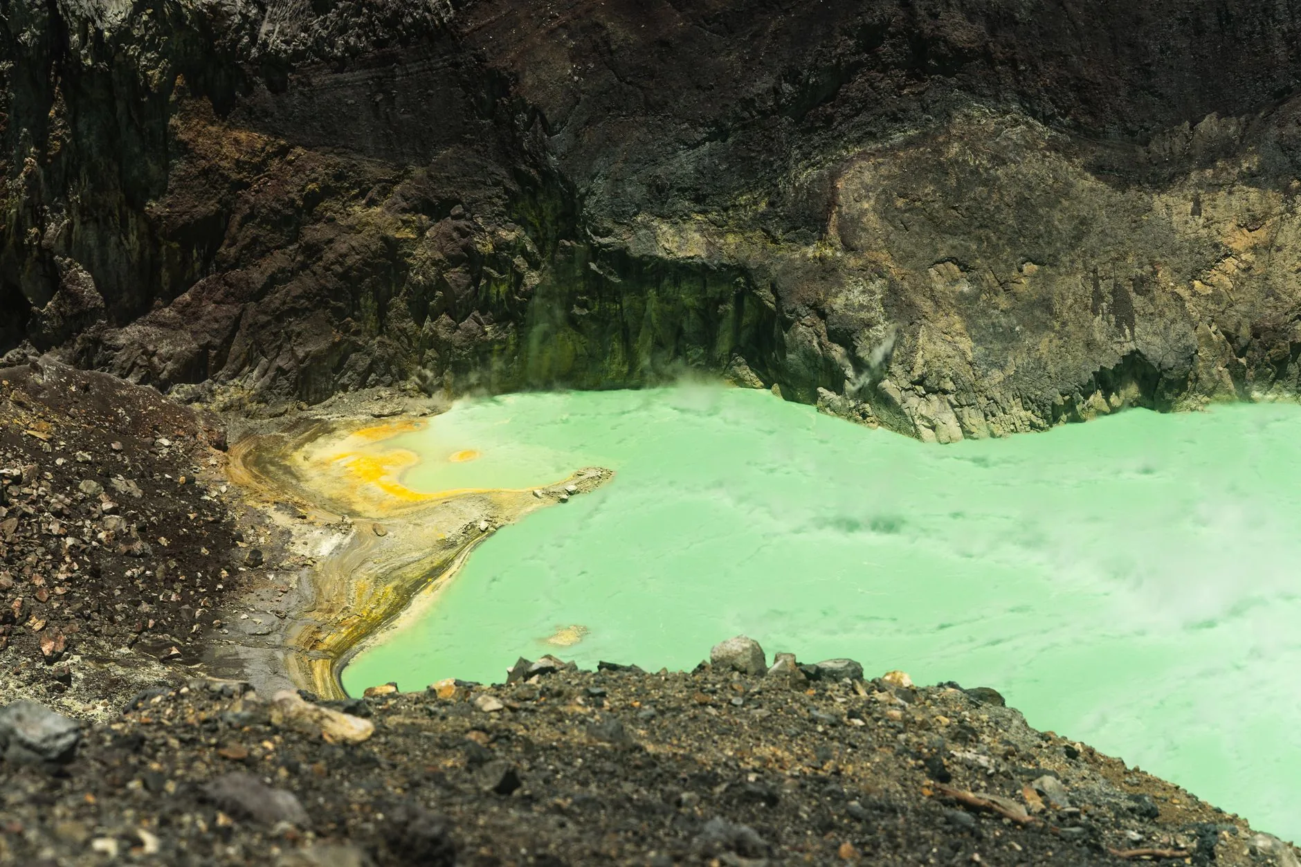
Boiling Lake & Valley of Desolation

🇩🇲 Dominica · Morne Trois Pitons National Park, Eastern Caribbean

Boiling Lake & Valley of Desolation

Manantiales / Boiling Lake & Valley of DesolationSprings / Boiling Lake & Valley of Desolation温泉・鉱泉 / Boiling Lake & Valley of Desolation

♨ Temperatura

92°C

⛰ Altitud

760 m

⚗ pH

2.5

💧 TDS

6400 mg/L

🌊 Caudal

N/A (volcanic vent lake)

📅 Establecido

Reported by European observers in 1870s; national park established 1975

♨ Temperature

92°C

⛰ Altitude

760 m

⚗ pH

2.5

💧 TDS

6400 mg/L

🌊 Flow rate

N/A (volcanic vent lake)

📅 Established

Reported by European observers in 1870s; national park established 1975

♨ 温度

92°C

⛰ 標高

760 m

⚗ pH

2.5

💧 TDS

6400 mg/L

🌊 流量

N/A (volcanic vent lake)

📅 開設

Reported by European observers in 1870s; national park established 1975

VolcanicHot LakeFumarolicNatural Mineral Pool🏛 Patrimonio de la UNESCO🏛 UNESCO World Heritage🏛 世界遺産

✓ Verificado el 2026-07-22

✓ Verified on 2026-07-22

✓ 確認日 2026-07-22

Dominica es la isla más volcánicamente activa del Caribe Oriental, y el Lago Hirviente es su rasgo geológico más extraordinario: una fumarola inundada con agua hirviendo a unos 92°C, velada en vapor. El acceso requiere un día completo de trekking guiado de 13 km por el Valle de la Desolación, un paisaje volcánico sulfuroso de fumarolas, piscinas de barro hirviente y ventilaciones volcánicas. Todo el conjunto forma parte del Parque Nacional Morne Trois Pitons, Patrimonio Mundial de la UNESCO desde 1997.

Dominica is the most volcanically active island in the Eastern Caribbean, and the Boiling Lake is its most extraordinary geological feature. The lake is a flooded fumarole — a volcanic vent filled with boiling, bubbling water, typically grey-blue and perpetually veiled in a cloud of steam, sitting at approximately 92°C at its centre. Access requires a full-day guided trek of around 13 kilometres through the Valley of Desolation, a sulphurous highland landscape of fumaroles, boiling mud pools, hot springs, and volcanic vents. The valley earns its name from the eerie silence of a landscape largely devoid of vegetation, broken only by the hiss of steam and the gurgle of acidic water. Dominica is sometimes called 'the Nature Island of the Caribbean' for the density of its rainforest, volcanic terrain, and freshwater systems. The island has 365 rivers — one for every day of the year, it is said. The entire geothermal zone is part of Morne Trois Pitons National Park, a UNESCO World Heritage Site inscribed in 1997.

Boiling Lake & Valley of DesolationはDominica・Morne Trois Pitons National Park, Eastern Caribbeanに位置する鉱泉。源泉温度は92℃、標高760mの地に湧出する。泉水は強酸性(pH約2.5)の泉質、硫酸塩泉・二酸化炭素を豊富に含む、総溶解固形物6400 mg/Lが特徴だ。1975年創業。地質遺産・大自然体験など多様な温浴療法が行われる。施設ではガイド付きトレッキング・硫黄蒸気浴などが体験できる。

Minerales

Minerals

ミネラル

Sulphate2800 mg/L
Chloride980 mg/L
Silica640 mg/L
Sodium880 mg/L
Carbon Dioxide1400 mg/L
Iron18 mg/L

Tratamientos

Treatments

トリートメント

Geological heritageWilderness experience

Técnicas

Techniques

技法

Guided trekkingSulphurous steam exposure

Patrimonio

Dominica fue la última isla caribeña en ser colonizada por los europeos, en gran parte debido a la feroz resistencia del pueblo kalinago (caribe), que mantuvo el control de gran parte de la isla hasta bien entrado el siglo XVIII. El Territorio Kalinago —una reserva de 3700 acres establecida en 1903— en la costa noreste de la isla es el único territorio que queda en el Caribe oriental gobernado por comunidades kalinago. El paisaje volcánico, incluida la zona geotérmica, tiene un significado especial en la tradición oral kalinago.

Heritage

Dominica was the last Caribbean island to be colonized by Europeans, owing largely to the fierce resistance of the Kalinago (Carib) people, who retained control of much of the island well into the 18th century. The Kalinago Territory — a 3,700-acre reserve established in 1903 — on the island's northeastern coast is the only remaining territory in the Eastern Caribbean governed by Kalinago communities. The volcanic landscape, including the geothermal zone, holds significance in Kalinago oral tradition.

文化財

ドミニカ国は、カリブ海の島々の中で最後にヨーロッパ人による植民地化を受けた島であり、これは18世紀に入ってもなお島の大部分を支配し続けたカリナゴ(カリブ)族の激しい抵抗によるところが大きい。島の北東海岸に位置する「カリナゴ準州」―1903年に設立された3700エーカーの保留地―は、東カリブ海地域でカリナゴ・コミュニティによって統治される唯一残存する領域である。地熱地帯を含む火山景観は、カリナゴの口承伝承において重要な意味を持つ。

Cultura

El Boiling Lake (Lago Hirviente) de Dominica fue reportado por primera vez en la literatura científica occidental por H. A. Nicholls y Edmund Watt en 1875. El lago se ha drenado, desinflado y vuelto a llenar periódicamente —de forma más dramática en 2004— a medida que las presiones volcánicas profundas se desplazan bajo el complejo volcánico de Morne Trois Pitons. La escasa infraestructura turística de la isla, en comparación con sus vecinas, ha preservado tanto su ecosistema como su singularidad cultural.

Culture

Dominica's Boiling Lake was first reported in Western scientific literature by H.A. Nicholls and Edmund Watt in 1875. The lake has periodically drained, deflated, and refilled — most dramatically in 2004 — as deep volcanic pressures shift beneath the Morne Trois Pitons volcanic complex. The island's low tourism infrastructure, relative to its neighbours, has preserved both its ecosystem and its cultural distinctiveness.

文化

ドミニカ国の沸騰湖(ボイリング・レイク)は、1875年にH・A・ニコルズとエドムンド・ワットによって初めて西洋の科学文献に報告された。この湖は、モーン・トロワ・ピトン火山群の地下深くの火山圧力の変動に伴い、周期的に水位が下がったり、しぼんだり、再び満ちたりしてきた―2004年には特に劇的な変化が見られた。近隣諸島と比べて観光インフラが未発達であることが、この島の生態系と文化的独自性の両方を保ってきた。

Sostenibilidad

El Parque Nacional Morne Trois Pitons abarca 6857 hectáreas y constituye el área protegida central de Dominica. Su inscripción en la UNESCO reconoce específicamente los excepcionales valores volcánicos y de biodiversidad del parque. Dominica ha seguido una estrategia a largo plazo para posicionarse como destino de ecoturismo en lugar de turismo de masas, incluido el compromiso de convertirse en la primera nación climáticamente resiliente del mundo tras los daños catastróficos causados por el huracán María en 2017.

Sustainability

Morne Trois Pitons National Park covers 6,857 hectares and is Dominica's core protected area. The UNESCO inscription specifically recognizes the park's outstanding volcanic and biodiversity values. Dominica has pursued a long-term strategy of positioning itself as an eco-tourism destination rather than mass-market tourism, including a commitment to become the world's first climate-resilient nation after Hurricane Maria caused catastrophic damage in 2017.

持続可能性

モーン・トロワ・ピトン国立公園は6857ヘクタールに及び、ドミニカ国の中核的な保護区域となっている。ユネスコの登録は、この公園が持つ卓越した火山および生物多様性の価値を特に評価したものである。ドミニカ国は、大衆観光ではなくエコツーリズムの目的地としての立ち位置を確立する長期戦略を追求しており、2017年にハリケーン・マリアが壊滅的な被害をもたらした後、世界初の「気候変動に強靭な国家」となることを目指す取り組みもその一環である。

Contacto

Teléfono+1 767-448-2033

Sitio webwww.dominica.dm

DirecciónMorne Trois Pitons National Park, Laudat, Dominica

Contact

Phone+1 767-448-2033

Websitewww.dominica.dm

AddressMorne Trois Pitons National Park, Laudat, Dominica

連絡先

電話+1 767-448-2033

ウェブサイトwww.dominica.dm

住所Morne Trois Pitons National Park, Laudat, Dominica

← Volver al directorio completo Ver en el mapa interactivo← Back to the full directory View on the interactive map← ディレクトリ全体に戻る インタラクティブマップで見る